
Canon del Sumidero and the limestone walls above the Grijalva
Published on 09/24/2026 at 07:29 | Editorial responsibility: Rafael Müller, Editor-in-Chief AD HOC NEWS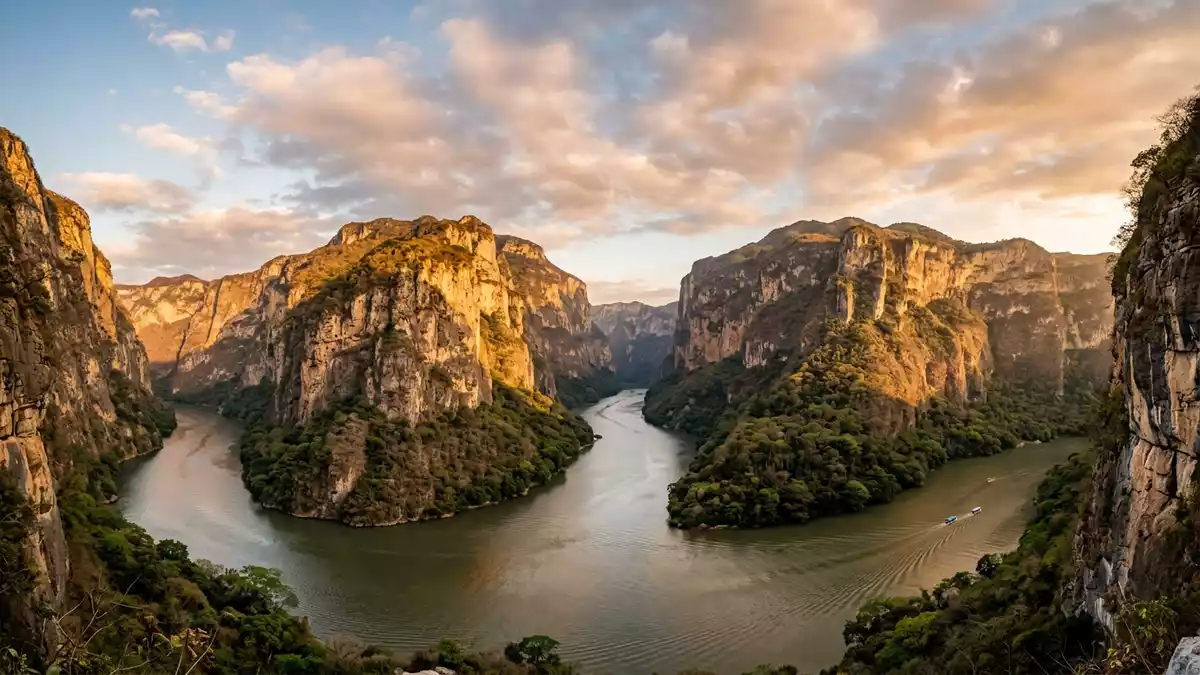
Canon del Sumidero is a deep river gorge north of Chiapa de Corzo in Chiapas, Mexico. The Grijalva River runs between limestone walls that rise to around 1,000 m (3,281 ft), creating a landscape where water, rock and tropical vegetation occupy the same narrow corridor.
Canon del Sumidero: a river beneath limestone walls
The canyon extends for roughly 30 km, while its width varies from about 1 to 2 km. From the river, the cliffs appear as long exposed faces, interrupted by vegetation, caves, ledges and waterfalls.
The river is the main visible line through the gorge. It enters from the upper reaches of Chiapas and continues through the canyon before joining the wider river system of southeastern Mexico. The national park designation dates from 8 December 1980.
The geology recorded in Canon del Sumidero
The canyon walls expose limestone layers from the Upper Mesozoic. Marine fossils occur within the rock, recording a geological period when this part of Chiapas lay beneath a shallow sea.
The gorge developed through movements in the Earth’s crust and erosion by the Grijalva River. Geological descriptions place the opening of the fault at roughly twelve million years ago, while the limestone itself is far older. The result is a vertical landscape in which ancient seabed material rises above a living river.
The walls vary in height along the route. Many sections rise between 200 and 700 m, while the highest cliffs reach around 1,000 m. The canyon’s scale is easiest to understand from the water, where the river occupies the bottom of the gorge and the upper rim remains far above.
Forest, water and wildlife in Chiapas
Canon del Sumidero lies within a protected area covering 21,789 hectares across parts of several municipalities. The park includes the river corridor, canyon slopes, forested areas and viewpoints above the gorge.
Vegetation changes across the protected landscape, with dry forest and mixed woodland appearing along the slopes. The river and surrounding habitats support species including American crocodiles and spider monkeys. Caves, waterfalls and rock ledges add further detail to the canyon walls.
Chiapa de Corzo provides the clearest town reference for the southern end of the gorge. Tuxtla Gutiérrez lies nearby, while the park extends across a wider part of central Chiapas. The protected-area profile records the canyon’s viewpoints, water bodies and wildlife.
Visiting Canon del Sumidero: what travellers from Western Europe should know
- Canon del Sumidero lies north of Chiapa de Corzo in Chiapas. River access runs through the Grijalva corridor, while roads reach viewpoints on the canyon rim.
- The landscape combines a river route with steep canyon walls. A boat journey and a viewpoint visit present different elevations and perspectives.
- The protected area includes water, cliffs, caves, waterfalls and forested slopes. The canyon floor and rim are separate environments within the same park.
- The official language is Spanish and the currency is the Mexican peso.
- Entry requirements depend on your nationality; UK travellers can check the FCDO travel advice at gov.uk/foreign-travel-advice, Irish travellers the Department of Foreign Affairs at ireland.ie.
Searching for Canon del Sumidero on social platforms
These links open searches for Canon del Sumidero on each platform.
Frequently asked questions about Canon del Sumidero
Where is Canon del Sumidero?
Canon del Sumidero is in Chiapas, southern Mexico, immediately north of Chiapa de Corzo. The gorge lies within Parque Nacional Cañón del Sumidero.
What can a visit include?
A visit can combine the Grijalva River corridor with viewpoints above the canyon. These settings reveal the water, cliffs, forest, caves and waterfalls from different levels.
What makes Canon del Sumidero distinctive?
The canyon brings Upper Mesozoic limestone, marine fossils, a major river and cliffs reaching around 1,000 m into one protected landscape.


