
Danakil Depression: a salt plain shaped by active rifting
Published on 09/23/2026 at 21:45 | Editorial responsibility: Rafael Müller, Editor-in-Chief AD HOC NEWS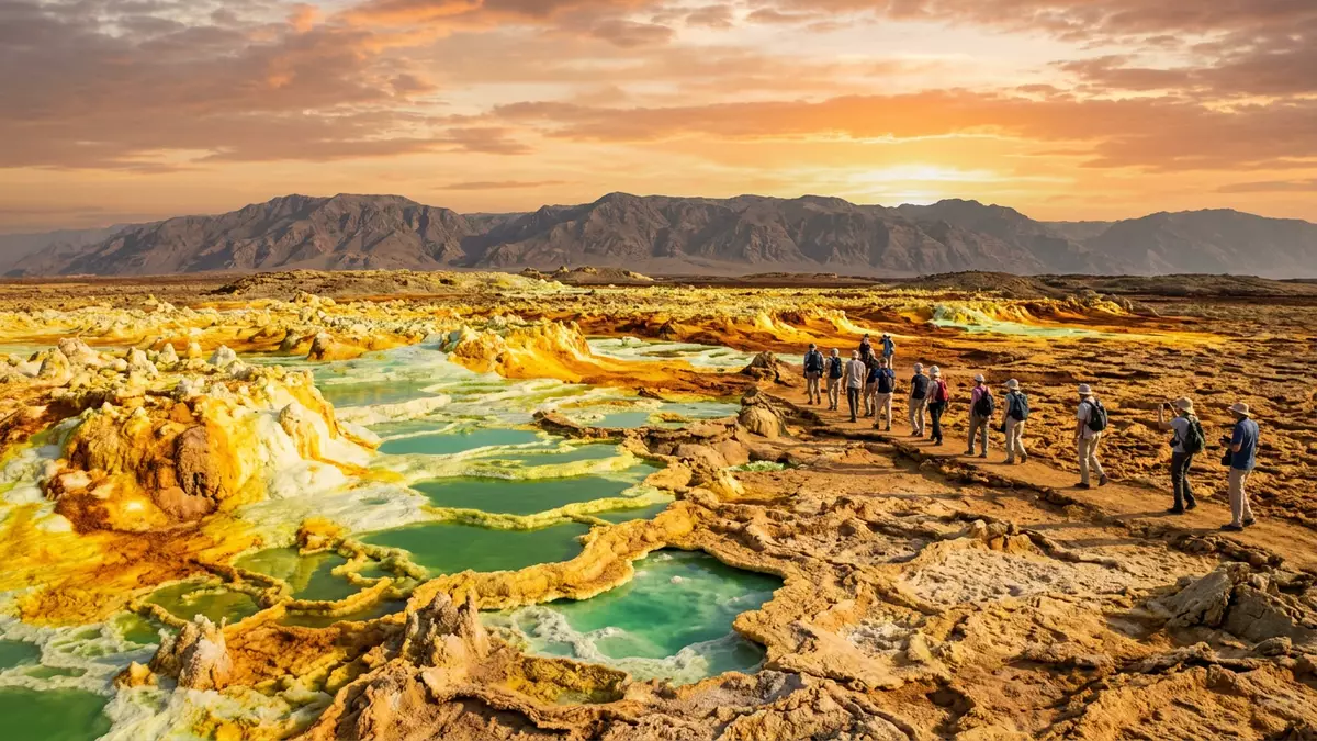
Danakil Depression is a vast salt basin in north-eastern Ethiopia, close to the border with Eritrea. Around Dallol, the landscape combines salt flats, raised salt formations, acidic brine pools and geothermal vents in a setting shaped by active rifting.
The basin reaches about 120 m below sea level, while Dallol rises above the surrounding salt plain as a dome of halite and anhydrite. Its visible colours come from minerals, brines and geothermal deposits rather than painted surfaces or artificial structures.
Dallol and the salt plain below sea level
Danakil Depression forms the northern part of the Afar Depression, a tectonic region linked with the East African Rift System. The basin lies between the Ethiopian Plateau to the west and the Danakil Alps to the east.
The depression covers a roughly triangular area of about 50,000 km². Its northern salt plain forms the deepest part, reaching approximately 120 m below sea level, while volcanic ranges occupy parts of the southern basin. the northern salt plain records the long history of evaporation and sediment accumulation.
Rifting began in the Miocene, about 30 million years ago, and continues within the Afar region. The Red Sea, Gulf of Aden and Main Ethiopian Rift meet in the wider Afar tectonic setting, where continental crust is being stretched and thinned.
Salt is the dominant surface material around Dallol. Halite, gypsum, anhydrite and other evaporite minerals formed from seawater and later lake systems. Flooding, evaporation and renewed precipitation have repeatedly altered the salt crust.
Dallol’s coloured geothermal formations
Dallol is a raised geological dome composed mainly of salt deposits. A central depression gives the dome a crater-like appearance, while salt canyons, pinnacles and ridges occupy its flanks.
The dome rises several dozen metres above the salt plain. Its formations include bedded halite, anhydrite, gypsum, clay and younger deposits created by geothermal activity. Dallol’s salt dome is associated with a hydrothermal system rather than a conventional lava-built volcano.
Hot springs, fumaroles, small geysers and brine pools occur across the dome. Their water can be strongly acidic and highly saline, while deposits around the vents form terraces, cones, pillars and delicate crusts.
Yellow, orange, green, white and brown surfaces appear in close proximity. Sulphur, iron, manganese and different salt minerals contribute to the changing palette. Some pools contain brines with pH values at or below 0 and temperatures that can approach the boiling point.
The geothermal formations are not fixed monuments. Salt dissolves, precipitates and collapses, while brine levels change within the hydrothermal field. A pool, chimney or salt terrace can therefore have a different form from one period of observation to another.
A landscape of rifting, evaporation and salt mining
The Danakil Depression records several geological environments in one basin. Basaltic volcanic ranges, ancient shorelines, salt plains, lake deposits and geothermal features occupy different parts of the region.
Marine incursions entered the basin during the Pleistocene. Their evaporation left thick sequences of salt and gypsum. Later lake systems deposited marls, clays and gypsum, while erosion shaped the margins and exposed older layers.
Traditional salt extraction forms part of the region’s cultural landscape. Afar workers have quarried salt and cut rectangular blocks for transport across the desert. Camels and donkeys have been associated with this trade, linking the salt plain with settlements on the Ethiopian escarpment.
Industrial potash exploration also left traces around Dallol. Mining activity during the twentieth century created an abandoned camp and associated industrial remains, adding a human layer to a landscape dominated by evaporites and geothermal change.
Beyond Dallol, the wider depression includes Lake Assale, the Erta Ale volcanic range, Black Mountain, Yellow Lake and other salt and hydrothermal formations. Erta Ale belongs to the active volcanic landscape of the Afar region, while Dallol is distinguished by its salt dome and acidic geothermal ponds.
The geological importance of Danakil Depression lies in the combination of processes visible at the surface. Rift movements, volcanic activity, groundwater circulation, evaporation and salt deformation are represented across a single broad basin.
Visiting Danakil Depression: what travellers from Western Europe should know
- Danakil Depression lies in the Afar Region of north-eastern Ethiopia. Dallol is reached across the desert and salt plain from the southern approach through the Afar lowlands.
- The terrain consists of salt crust, loose blocks, mud, exposed evaporites and geothermal ground. Walking routes around Dallol include uneven surfaces and areas beside acidic pools and fumaroles.
- The depression is a high-risk geothermal environment. Hot brines, unstable salt formations, gases and extreme heat occur around Dallol and Black Mountain.
- The official language is Amharic and the currency is the Ethiopian birr.
- Entry requirements depend on your nationality; UK travellers can check the FCDO travel advice at gov.uk/foreign-travel-advice, Irish travellers the Department of Foreign Affairs at ireland.ie.
- Conditions on the mountain change with the seasons; the local cable-car operators and alpine clubs provide information.
Searching for Danakil Depression on social platforms
These links open searches for Danakil Depression on each platform.
Frequently asked questions about Danakil Depression
Where is Danakil Depression?
Danakil Depression lies in north-eastern Ethiopia, in the Afar Region near the border with Eritrea. Dallol is located in the northern part of the depression.
What can visitors expect at Dallol?
The landscape includes salt flats, uneven evaporite ground, acidic brine pools, fumaroles, geysers and changing geothermal deposits. Heat and hazardous ground conditions are central features of the setting.
What makes Danakil Depression distinctive?
It brings together a deep salt basin, active rifting and an exceptionally varied geothermal landscape. Dallol’s coloured ponds and salt formations sit within a wider region shaped by evaporation, volcanism and tectonic movement.


