
Lago Titicaca: water, islands and high Andean horizons
Published on 09/24/2026 at 11:36 | Editorial responsibility: Rafael Müller, Editor-in-Chief AD HOC NEWS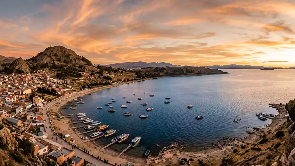
Lago Titicaca spreads across the Andes between Bolivia and Peru, with Copacabana on the Bolivian shore. Water, islands and mountain horizons meet at an elevation of about 3,810 m (12,500 ft), giving the lake a geography unlike an ordinary lakeside landscape.
Lago Titicaca between Bolivia and Peru
The lake occupies a broad basin on the Altiplano, the high plateau of the central Andes. Its surface covers about 8,300 sq km, and the water extends roughly 190 km from end to end, reaching about 80 km across at its widest point. These dimensions turn the view from Copacabana into a wide geographical scene rather than a small coastal outlook.
Lago Titicaca is recognised as the world’s highest lake navigable to large vessels. Its elevation is a physical fact of the landscape, visible in the bare slopes, open plateau and distant mountain ridges around the water. The lake’s western side lies in Peru, while its eastern and southern reaches belong to Bolivia. Lake Titicaca’s geography includes a long northwest-to-southeast form and numerous inhabited islands.
Copacabana and the islands offshore
Copacabana lies on a peninsula projecting into the southern part of Lago Titicaca. The town is associated with the Virgin of Copacabana, whose veneration developed during the late sixteenth century. Its basilica and pilgrimage traditions place Catholic devotion beside older Andean connections with the lake.
Isla del Sol lies near the tip of the Copacabana Peninsula and is the largest island in Lago Titicaca. Terraced hillsides, stone remains and paths cross its inhabited landscape. Across the lake, islands rise from the water in different forms, linking settlement, agriculture and ritual history. Titicaca’s sacred history includes its place in the traditions of the Tiwanaku civilisation and the Inca Empire.
Tiwanaku, Inca traditions and living landscapes
Lago Titicaca belongs to a cultural landscape shaped by Andean societies across many centuries. The Tiwanaku civilisation reached its height between 600 AD and 1050 AD, while the Inca Empire reached its height during the fifteenth and sixteenth centuries. Their histories connect the lake with religious traditions, political power and settlements around the high basin.
Archaeological traces appear on islands and along the shores, while farming terraces and local communities remain part of the wider landscape. UNESCO investigations have documented submerged cultural sites and objects linked to Tiwanaku and Inca periods. Underwater cultural remains add another layer to the visible world of open water, reed beds, stonework and mountain settlements.
From Copacabana, the lake appears as both a natural basin and a cultural route. Boats connect the peninsula with islands and shore communities, while the changing outline of the water reveals the scale of the Altiplano. The combination of altitude, distance and human history gives Lago Titicaca its distinctive character.
Visiting Lago Titicaca: what travellers from Western Europe should know
- Copacabana stands on the Bolivian shore of Lago Titicaca, north-west of La Paz. Road travel connects the town with La Paz, and boats leave the lakeside area for islands including Isla del Sol.
- The lake and Copacabana lie at about 3,810 m (12,500 ft) above sea level. Walks around the town, peninsula and island terrain include slopes, steps and high-altitude ground.
- The official language is Spanish, alongside Indigenous languages including Aymara and Quechua, and the national currency is the boliviano.
- Entry requirements depend on your nationality; UK travellers can check the FCDO travel advice at gov.uk/foreign-travel-advice, Irish travellers the Department of Foreign Affairs at ireland.ie.
Searching for Lago Titicaca on social platforms
These links open searches for Lago Titicaca on each platform.Frequently asked questions about Lago Titicaca
Where is Lago Titicaca?
Lago Titicaca lies in the Andes on the border between Bolivia and Peru. Copacabana is a Bolivian lakeside town on a peninsula in the southern part of the lake.
What can travellers expect around Copacabana?
The area combines a high-altitude lakeshore, mountain views, island boat routes, archaeological remains and the pilgrimage tradition of the Virgin of Copacabana.
What makes Lago Titicaca distinctive?
Its elevation of about 3,810 m (12,500 ft), large navigable waters, islands and deep links with Tiwanaku and Inca history define the lake’s character.


