
Namaqualand near Springbok and its shifting desert colours
Published on 09/16/2026 at 22:54 | Editorial responsibility: Rafael Müller, Editor-in-Chief AD HOC NEWS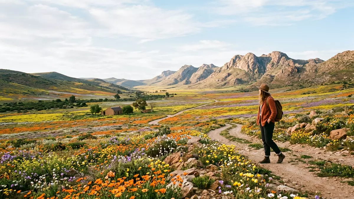
Namaqualand around Springbok in South Africa’s Northern Cape is a semi-arid landscape where granite hills, sandy plains and low shrubs form a wide valley that changes character when wildflowers appear. Springbok, originally called Springbokfontein in the nineteenth century, anchors this part of Namaqualand as its chief town and administrative centre.
Northern Cape desert belt along the west coast
Namaqualand is a geographic region of south-western Africa that extends along the Atlantic side of the continent between the Namib desert and the Kalahari.Geographic region Its South African portion lies in the Northern Cape province, on the dry western flank of the country where rainfall is limited and the terrain tends towards semi-desert shrubland rather than dense grass or forest.South African portion lies in the Northern Cape Within this belt, Springbok stands out as the main town for the South African side, acting as a hub for administration and services.
Springbok is described as the largest town in the Namaqualand area in the Northern Cape, serving as its chief town and practical centre.Largest town in the Namaqualand area The town lies in a valley surrounded by low hills and rocky outcrops, a setting that makes the built-up area visible as a cluster against otherwise open country.Valley surrounded by hills Around it, Namaqualand stretches for long distances, with the land gradually shifting from inland hills to more coastal plain and dune country further west.
Springbok, mining history and flower routes
The town of Springbok developed in the nineteenth century as a copper mining centre for the surrounding district, a role that tied it closely to towns such as Okiep and Aggeneys where ore deposits are worked.Copper has been mined at Springbok Copper mining shaped both the town’s growth and its infrastructure, with roads and services radiating into the hills where shafts and workings were established. The mining story remains visible in the area’s identity, even as many visitors now associate Springbok with desert scenery and wildflowers rather than ore.
Namaqualand around Springbok is part of a wider “flower route” described for the Northern Cape, where seasonal flowering transforms semi-arid ground.Wild Flower Route through Northern Cape The Namaqualand-Blutenroute name points specifically to wildflower routes in the Springbok area, tying roadside displays, nature reserves and farm tracks into an informal circuit rather than a single signed highway.Namaqualand-Blutenroute refers to the famed flower route Skilpad within Namaqua National Park and nearby reserves such as Goegap Nature Reserve feature regularly in descriptions of this circuit, forming recognisable points along a broad band of countryside.
Semi-desert that turns into flowers
For much of the year, land around Springbok reads as semi-arid: granite boulders, sandy soil and hardy shrubs dominate the hills and plains, with patches of bare ground between bushes.Granite hills, sandy plains and low shrubs The region sits within the Succulent Karoo biome, known for drought-resistant plants that store water and tolerate strong sun. Roads such as the N7 and R355 cross this landscape on long, gently curving alignments, giving drivers extended views across open country.
In the flowering period described for Namaqualand, thousands of species are recorded across the wider region, with annual daisies particularly associated with Springbok and its surroundings.More than 3 500 floral species emerge During this phase, verges, farm fields and reserve plateaux carry carpets of colour that overlay the underlying rock and scrub. The same valley where shrubs stand apart from one another can, in the flowering season, appear filled with closely spaced blooms, turning a semi-desert into sheets of flowers as seen from nearby hills.Semi-desert that turns into vast sheets of wildflowers
Visiting Namaqualand: what travellers from Western Europe should know
- Namaqualand in this sense lies in South Africa’s Northern Cape province, with Springbok as its chief town and administrative centre on the road corridor linking Cape Town with Namibia.
- Springbok stands in an arid valley ringed by rocky hills and plains, and exploring the surrounding flower routes and reserves involves travel on tarred main roads and gravel side roads.
- The wider Namaqualand landscape around Springbok combines semi-desert shrubland, granite outcrops and occasional dune or coastal plain further west, so footwear and clothing need to suit dry, uneven ground.
- The official language is Afrikaans and English is also widely used; the currency is the South African rand.
- Entry requirements depend on your nationality; UK travellers can check the FCDO travel advice at gov.uk/foreign-travel-advice, Irish travellers the Department of Foreign Affairs at ireland.ie.
Searching for Namaqualand on social platforms
These links open searches for Namaqualand on each platform.
Frequently asked questions about Namaqualand
Where is this part of Namaqualand located?
This article refers to the South African portion of Namaqualand in the Northern Cape province, centred on the town of Springbok as its chief settlement.
What can visitors expect around Springbok?
Visitors encounter semi-arid valleys with granite hills, dry plains and shrubland that, during the flowering period, can be covered by extensive wildflower displays along roads and in reserves.
What makes Namaqualand near Springbok distinctive?
The contrast between long stretches of semi-desert terrain and the seasonal transformation into colourful wildflower carpets gives Namaqualand around Springbok a character strongly tied to both geology and plant life.


