
Rock Islands and the lagoon of limestone domes near Koror
Published on 08/26/2026 at 08:17 | Editorial responsibility: Rafael Müller, Editor-in-Chief AD HOC NEWS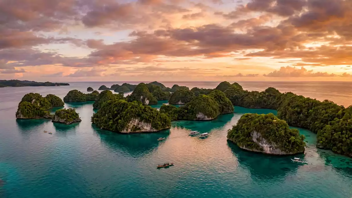
Rock Islands in Koror, Palau, form a dense cluster of forested limestone domes rising from a shallow turquoise lagoon, an island landscape shaped as much by water as by rock. Recognised as the Rock Islands Southern Lagoon on the UNESCO World Heritage List in 2012, the area combines a maze of small islands, sheltered channels and enclosed marine lakes.
Limestone domes in a sheltered southern lagoon
The Rock Islands occupy a broad swathe of Palau’s Southern Lagoon between the main island of Babeldaob and the smaller island of Peleliu, south of the town of Koror. The archipelago lies within Koror State and is part of the wider barrier reef system that frames this section of the western Pacific Ocean.Rock Islands Southern Lagoon The official World Heritage documentation describes the property as a predominantly marine site, with the islands scattered inside a protected lagoon.
Most of the islands are raised limestone features, their bases undercut by wave action into profiles that resemble inverted mushrooms when seen from the water.The Rock Islands of Palau Rainwater and the tropical climate support dense forest on the upper slopes, so that from a distance the landforms appear as rounded green domes sitting above the lagoon. Beneath the surface, the lagoon floor carries patch reefs and channels, linking shallow coral gardens with deeper passages used by boats.
A World Heritage seascape of reefs, caves and lakes
The Rock Islands Southern Lagoon covers an area of about 100,200 ha and includes hundreds of uninhabited islands surrounded by coral reefs and shallow marine habitats.World Heritage datasheet for Rock Islands Southern Lagoon The marine setting supports a wide range of coral species and fish, including reef walls, drop-offs and sheltered coral gardens where the lagoon shallows meet the ocean-facing barrier reef. The contrast between the steep limestone sides of the islands and the flat lagoon floor gives many bays a clear boundary between land and sea.
Within the limestone mass of individual islands, erosion has created caves, overhangs and enclosed marine lakes connected to the lagoon by channels or fissures. Scientific descriptions of the site refer to dozens of such marine lakes, where seawater is partially isolated and forms distinct habitats inside the islands.Rock Islands Southern Lagoon World Heritage overview Archaeological work on islands such as Ulong and Ngemelis has identified rock art, cave burial sites and traces of earlier settlements, indicating that the Rock Islands also hold a cultural record alongside their natural features.
Jellyfish Lake and the inner waters of Eil Malk
One of the best-known individual features within the Rock Islands is Jellyfish Lake, known in Palauan as Ongeim’l Tketau, on the island of Eil Malk. It is a marine lake enclosed within the interior of the island, with its waters connected to the surrounding lagoon through channels in the limestone.Jellyfish Lake on Eil Malk The lake is described as a saltwater body several hundred metres long, with a depth that reaches tens of metres at its deepest point.
Jellyfish Lake is known for its dense population of golden jellyfish, which share the enclosed water with other marine species adapted to the lake environment.Jellyfish Lake in the Rock Islands The combination of a forested limestone island, a marine lake set inland and the surrounding lagoon captures the layered character of the Rock Islands as a whole: a landscape where open ocean, sheltered lagoon, enclosed lakes and steep forested slopes sit within short distances of one another.
Visiting Rock Islands: what travellers from Western Europe should know
- Rock Islands lie south of Koror in Palau’s Southern Lagoon, between the larger island of Babeldaob and the smaller island of Peleliu. Boat trips on the lagoon connect Koror with the islands.
- Many viewpoints, caves and lakes on the Rock Islands involve climbing over uneven limestone, using boat ladders or following paths up and down forested slopes.
- The Rock Islands are in Palau, where the official languages include Palauan and English, and the currency is the United States dollar.
- Rock Islands lie in a tropical region where rain showers and strong sun are both common in different parts of the year.
- Entry requirements depend on your nationality; UK travellers can check the FCDO travel advice at gov.uk/foreign-travel-advice, Irish travellers the Department of Foreign Affairs at ireland.ie.
Searching for Rock Islands on social platforms
These links open searches for Rock Islands on each platform.
Frequently asked questions about Rock Islands
Where are Rock Islands located?
Rock Islands lie in the Southern Lagoon of Palau, within Koror State, between the larger island of Babeldaob and the island of Peleliu.
What can visitors expect when exploring Rock Islands?
Visitors encounter forested limestone domes, coral reefs, sheltered channels and enclosed marine lakes, with many viewpoints and landing spots reached by boat and short walks.
What makes Rock Islands distinctive among island landscapes?
The combination of raised limestone islands, a protected lagoon, numerous marine lakes and archaeological sites gives Rock Islands a layered character that combines natural and cultural features.


