
Valle de la Luna and the geology of Chile’s Atacama Desert
Published on 09/24/2026 at 08:42 | Editorial responsibility: Rafael Müller, Editor-in-Chief AD HOC NEWS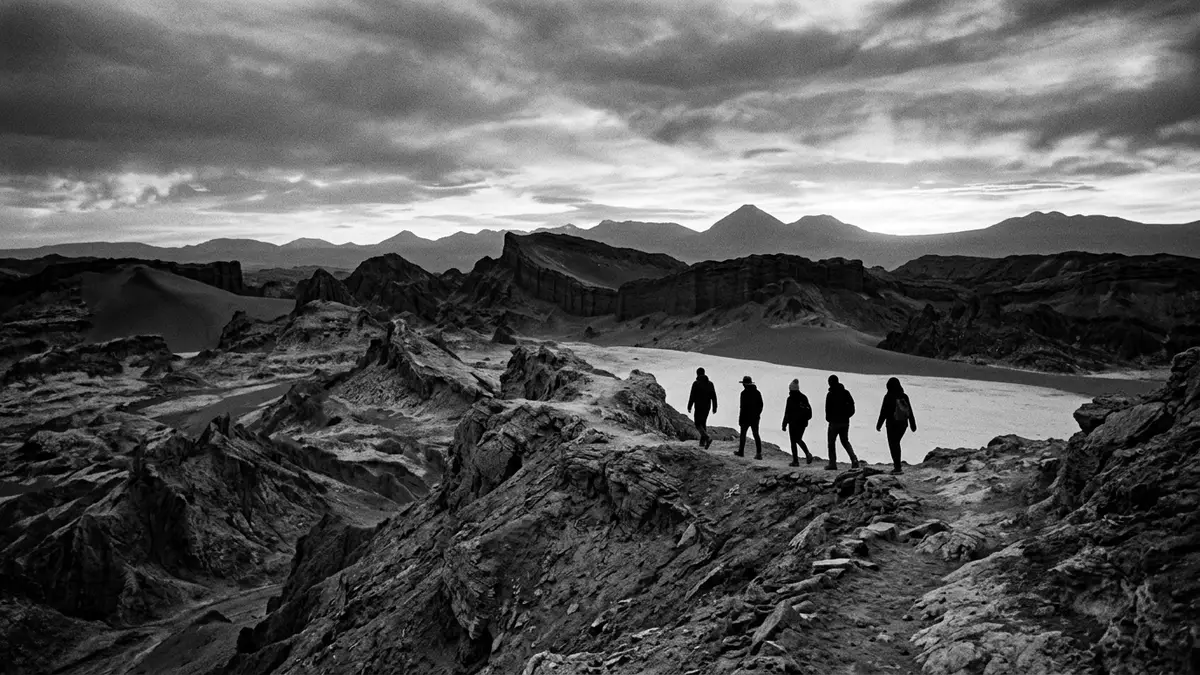
Valle de la Luna lies west of San Pedro de Atacama, where salt, gypsum, clay and sand form a desert landscape of ridges, hollows and exposed mineral layers. Within the Cordillera de la Sal, the valley presents the Atacama Desert as a sculpted geological basin rather than a flat expanse of sand.
Valle de la Luna: a basin of salt and folded rock
The valley belongs to the Cordillera de la Sal, or Salt Mountain Range, in northern Chile. It forms part of the Los Flamencos National Reserve and lies about 13 km west of San Pedro de Atacama. The official name of the landscape refers to its resemblance to the lunar surface, while its rocks preserve a much older terrestrial history.
The formation process began about 33 million years ago, when mineral and sedimentary materials accumulated in a basin. Water descended into the basin, evaporated, and left deposits that included salt, gypsum and fine sediments. Tectonic forces then folded and lifted these layers into the range visible around Valle de la Luna. This 33-million-year formation gives the valley its geological depth.
Ridges, dunes and named formations
Wind and water erosion have cut the uplifted deposits into narrow ridges, shallow channels, mounds and depressions. The surface contains pale salt crusts, grey and ochre sediment, gypsum layers, clay and sand. The result is a landscape of sharp edges beside smoother slopes, with mineral textures exposed across the valley.
Named formations include Tres Marías, the Amphitheatre, Gran Duna and the Cavernas de Sal. Gran Duna is a broad sand feature, while the salt caverns expose mineral material within the Cordillera de la Sal. These formations are not separate monuments but parts of the same eroded desert system. Valle de la Luna reaches roughly 2,500 m above sea level, giving its ridges and depressions an Andean setting.
The valley is also an endorheic landscape. In an endorheic basin, water remains enclosed rather than flowing directly to the sea. Evaporation concentrates dissolved minerals, leaving crusts and deposits that contribute to the pale surfaces of the valley. The named valley formations provide recognisable points within this wider geological setting.
A protected desert landscape near San Pedro
Valle de la Luna has held nature sanctuary status since 1982. Its protected terrain includes mineral crusts, salt formations, exposed sediment and fragile desert surfaces. The landscape belongs to a wider protected area associated with the Los Flamencos National Reserve, which also contains other desert and highland environments around San Pedro de Atacama.
The valley connects naturally with the cultural landscape of San Pedro de Atacama. The town lies in an oasis of the Chilean Highlands, while the surrounding region contains traces of Atacama communities, agricultural settlements and ancient routes. Valle de la Luna itself is a geological site, but its setting forms part of a territory shaped by desert adaptation and Andean movement across generations.
Its appearance changes across short stretches of ground. Salt-covered surfaces give way to sand, then to folded ridges and eroded walls. The colours remain restrained, moving through white, grey, beige, yellow, brown and ochre. In this compressed space, the material history of the Cordillera de la Sal remains visible in the terrain itself.
Visiting Valle de la Luna: what travellers from Western Europe should know
- Valle de la Luna lies west of San Pedro de Atacama in Chile’s Antofagasta Region. It can be reached from the town by road, bicycle, motor vehicle or organised excursion.
- The valley sits at about 2,500 m above sea level. Routes cross salt, sand, clay and uneven eroded ground, with named formations separated across the desert terrain.
- The surrounding desert has a marked difference between daytime and night-time temperatures. The Cordillera de la Sal remains an exposed landscape with little natural shelter.
- The official language is Spanish and the currency is the Chilean peso.
Searching for Valle de la Luna on social platforms
These links open searches for Valle de la Luna on each platform.
Frequently asked questions about Valle de la Luna
Where is Valle de la Luna?
Valle de la Luna is in northern Chile, about 13 km west of San Pedro de Atacama. It lies within the Cordillera de la Sal and the Los Flamencos National Reserve.
What can visitors expect to see?
The landscape contains salt crusts, gypsum, clay, sand, dunes, eroded ridges and named formations such as Tres Marías and Gran Duna. The terrain is exposed and uneven, with routes across a desert basin at about 2,500 m above sea level.
What makes Valle de la Luna distinctive?
Its folded mineral layers and eroded ridges create a lunar-looking landscape within the Atacama Desert. The valley combines salt, gypsum and clay in a protected geological setting near San Pedro de Atacama.


